Monks Hall
2024 Project Design
Archaeology is a very destructive process – once it’s gone from the ground, there’s no putting it back. That’s why we need to carefully balance the research aims of the excavation with the learning experience of the students. If we focus too heavily on the research, we may introduce skills gaps among participants. Likewise, if we prioritise teaching practical skills over sensitive archaeology in the ground, we run the risk of doing irreparable damage to our heritage.
Research aims
Our activities are designed to answer specific research questions. Everything we do on site is done to answer one of these broad research categories:
Understanding Cultural Heritage. Archaeological research aims to investigate and understand the cultural heritage of the site and its place within the local area. Exploring how people lived, their social structures, economies, belief systems, and interactions with their environment.
Preservation and Conservation. Preservation and conservation of archaeological sites and artefacts are crucial aims of the project. This involves not only excavating sites but also developing strategies for their preservation, conservation, and interpretation for future generations.
Advancing Knowledge and Scholarship. Archaeological research aims to contribute to the advancement of knowledge and scholarship in various fields, including archaeology, history, and related disciplines. This involves conducting rigorous research, employing innovative methodologies, and disseminating findings through academic publications, public outreach, exhibitions, and educational programs.
Curriculum
Our curriculum is designed around the core and secondary skills found in the Archaeology Skills Passport (BAJR). These aim to equip students with the essential skills and knowledge required to conduct archaeological fieldwork effectively:

Introduction to Fieldwork
- Overview of fieldwork in archaeology
- Introduction to excavation and survey techniques
- Site formation processes
- Health and safety considerations

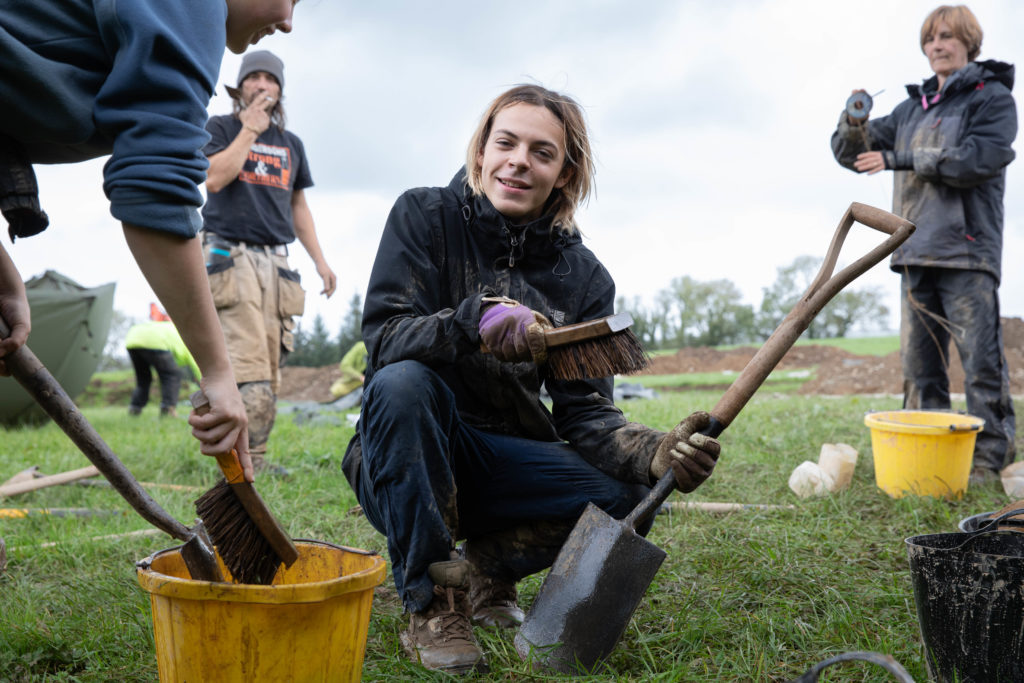
Excavation Skils
- Stratigraphic excavation methods
- Understanding and recording stratigraphy
- Use of hand tools (trowels, shovels, mattocks etc)
- Site photography and photogrammetry
Surveying Techniques
- Setting out a grid
- GNSS (global navigation satellite systems)
- Total station theodolite operation
- Geophysical survey methods (e.g., magnetometry, resistivity, radar etc)

Recording and Documentation
- Context recording
- Plan and section drawing
- Photographic documentation techniques
- Digital recording and database management
Post-Excavation Skills
- Artefact processing (cleaning, labelling, bagging)
- Basic artifact identification and cataloguing
- Environmental sampling (soil, flotation, pollen)
- Handling and storage of archaeological finds

Methods
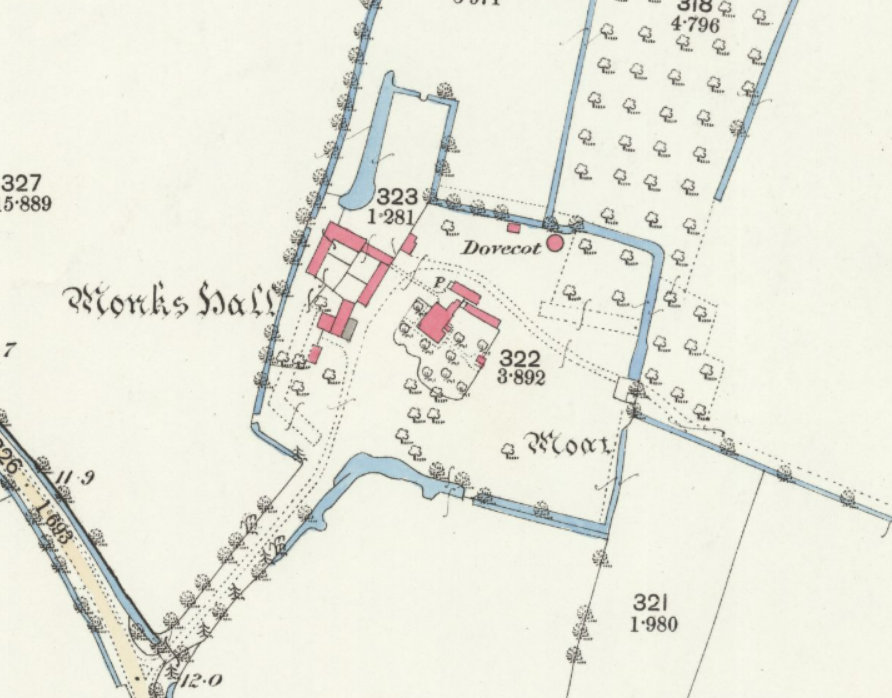
Trench 1 – Investigate the small, moated area in the back grass field. Previous work has yielded small fragments of early medieval pottery from directly beneath the topsoil. We’re going to open a large trench within the rectangular earthwork to see what’s there.
Trench 2 – Excavate the remains of the dovecote near the manor house. The building appears on some early maps of the farm but had disappeared long ago. We think we found it using Ground Penetrating Radar (GPR) – now it’s time to see if we’re right.
Trench 3 – Reveal the remains of the old, brick-built greenhouse. This one showed up clearly when we surveyed it in March. We do have photos of the building before it was demolished in the early 90s, but it’ll make a good test case for excavating and recording buildings.
Topographic survey – The grass fields are full of lumps and bumps, shallow depressions and moat-like earthworks. We will be surveying each and every one of them using basic (hand tape and ‘dumpy’ level), intermediate (GNSS and total stations) and advanced (Unmanned Aerial Vehicle (UAV)) methods.
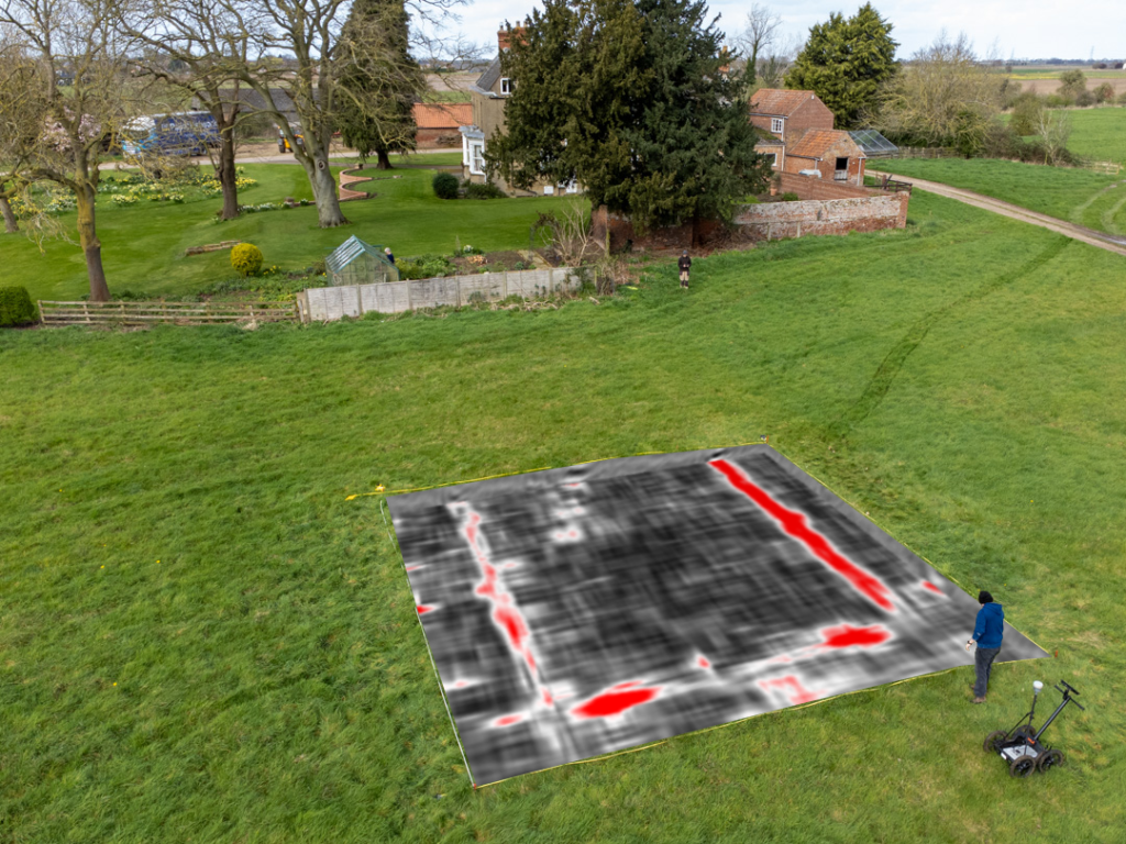
Geophysical survey – We’ve been working with Bishop Grosseteste University, Lincoln to see which geophysical techniques work best at identifying buried archaeology in the silt fen landscape. This work will continue throughout summer 2024 and we aim to survey as much of the grass fields as possible. We’ll be using magnetometry, resistivity, more GPR, and anything else we can get our hands on!
Artefacts – We expect to find plenty of medieval artefacts that will need cleaning, conserving and identifying. If we run out of finds on site, we have teaching collections to give people a flavour of what they can expect from a range of other archaeological sites.
Environmental – A flotation tank and environmental processing area will be running across all four weeks of the field school. We want to show students what’s really in the soil they’ve been digging, and what it can tell us about the past.

Maps

Monks Hall Grassfields

Monks Hall Manor

1m DTM

1776 estate plan

1886 1-inch Ordnance Survey

1950 1-inch Ordnance Survey

Landscape aerial image

2m DTM

Domesday settlements and 1307 coastline (after Hallam)