Projects
Explore some of our past work and ongoing projects
Lincoln Castle GPR Survey
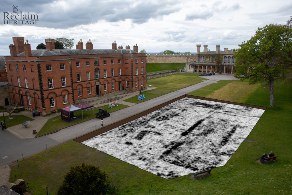
In May 2025, Reclaim Heritage conducted a non-invasive Ground Penetrating Radar (GPR) survey at Lincoln Castle to explore the hidden history beneath its iconic grounds. Using this cutting-edge technology, our team identified subsurface walls from the castle’s original gaol (prison) and structural remains of the early County Court. Most excitingly, we uncovered features roughly 2m below the surface that likely predate the Norman construction, potentially dating back to the Roman period. We are currently finalizing our data analysis and interpretation, and we look forward to publishing the full results in early 2026 to help inform future excavations and community engagement.
Copthill School, Uffington

Reclaim Heritage has been working with Copthill School to understand the archaeology and history of the area. Our investigations began in April 2024 when we excavated a grave in a gravel quarry near Copthill Farm, prompting a geophysical survey and small excavations nearby.
In September we found part of a Roman cemetery, a Roman farmstead and possible trackway, and roundhouses from an extensive, well-preserved Middle Iron Age settlement.
Fenland Landscape Survey
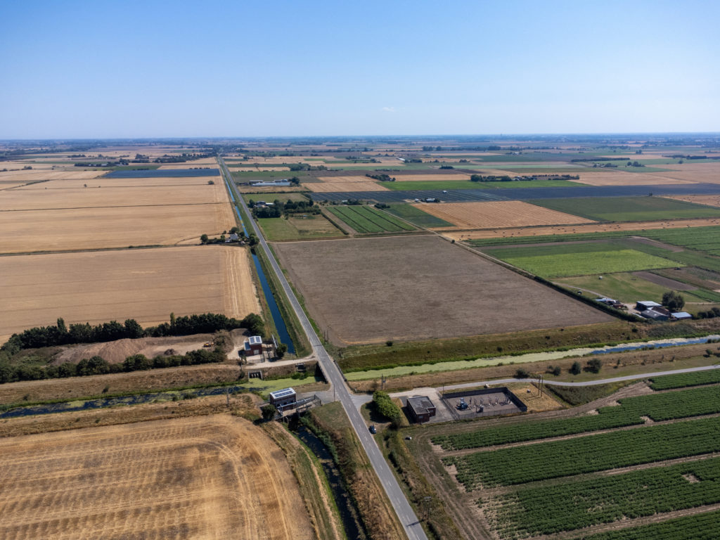
The Fenland Landscape Survey engages local volunteers of all ages and backgrounds to help map and interpret the historic landscape of South Lincolnshire, making the data open and accessible for all. Reclaim Heritage are looking to train participants in transferable digital skills while learning about the Fens’ rich and complex heritage.
By utilizing a variety of techniques (new and old), we can gain a better understanding of this complex and dynamic landscape’s history. These include digitisation and interpretation of historic maps and aerial images, onomastics, and landscape survey techniques.
* Beta version, not supported in some browsers
Veiled Landscape Project

The Veiled Landscape project is led by Nottinghamshire County Council with Reclaim Heritage CIC commissioned to process and analyse high resolution LiDAR data in advance of ground truthing events with volunteers in Sherwood Pines.
In total, over 62 km of linear earthworks were recorded and digitised from the LiDAR data analysed at Sherwood Pines. The vast majority of remains encountered during fieldwork can be attributed to the WWI training ground known as Clipstone Camp, although a small number of enclosures were recorded that predate this.
Church of St Stephen, Brough

Reclaim Heritage CIC was commissioned by Prospect Archaeology / Wake Conservation, on behalf of the Diocese of Southwell and Nottingham to undertake a programme of archaeological evaluation in advance of submitting proposals for conversion of the Church of St Stephen to a domestic dwelling.
Our work revealed extensive Roman ‘dark earth’ layers within the churchyard. These layers consistently measured over 1m deep, overlying poorly preserved stone flooring and complex stratigraphy. We recovered 297 sherds of later 2nd to 4th century pottery, 93 fragments of animal bone – including a Roman pin – 18 fragments of Roman building material, and seven iron nails.
Crowle Common Community Excavation

A geophysical magnetometry survey of Crowle Common was made to identify buried archaeological remains, followed by excavation of three trenches with members of the local community. One archaeological feature was found and investigated, most probably a Roman or Iron Age enclosure ditch, dated by a single sherd of Roman greyware pottery.
Participants gained a range of new skills including excavation, finds identification and processing, aerial survey, metal detecting and survey. When inclement weather forced outdoor activities to pause, volunteers received hands-on training in digital mapping (GIS), photography and learnt more about their local history.
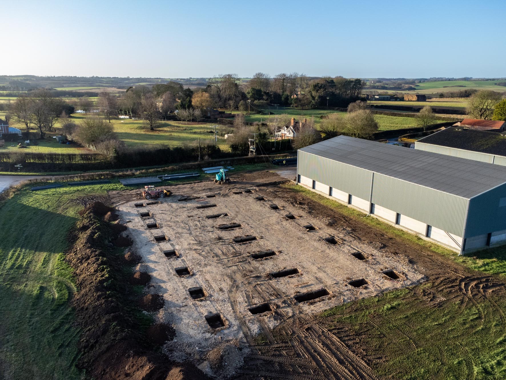
Aswardby House Farm

Reclaim Heritage CIC was commissioned by Prospect Archaeology Ltd on behalf of Hawkes Farms Ltd to undertake a programme of archaeological monitoring as a condition of Scheduled Monument Consent for the construction of a new grain store at Aswardby House Farm, Aswardby, Lincolnshire.
Archaeological monitoring revealed the presence of one Roman ditch in the base of a stanchion pit. The ditch was aligned east-to-west, corresponding broadly with the alignment of cropmarks identified to the north within the scheduled area. In total, five sherds of pottery were recovered: three sherds of Roman greyware, one small abraded sherd of prehistoric pottery, and one fragment from an 18th century bowl.